


Choppers take to the air over Geelong for Powercor’s vegetation program
26 April, 2022
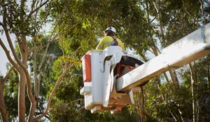
Powerline inspections from the air have begun in the Geelong area as part of electricity distributor Powercor’s year-round vegetation inspection and tree-cutting program.
The helicopters are fitted with advanced Light Detection and Ranging (LiDAR) technology to accurately scan for trees and branches growing near to powerlines. This information is fed back to experienced teams that will cut the vegetation away from powerlines to keep the network and community safe.
Powercor’s vegetation management program is the largest in the state, inspecting and managing vegetation across more than 70,000km of powerline through central, northern and western Victoria, including across hazardous bushfire risk areas.
Powercor Head of Vegetation Management, Chris Heinz, said the program was a critical part of keeping the network safe and reliable for customers.
“Our work is about reducing the risk of trees and branches coming into contact with powerlines, which can lead to power outages and fires,” Mr Heinz said.
“By inspecting the entire network every year, we are able to determine where and when we need to cut trees and branches away from powerlines,” he said.
Teams then attend each site, both on private and public property, to assess and scope what cutting needs to occur. If crews are required to cut trees on private property, Powercor will notify customers in advance of any cutting unless the work needs to occur immediately for safety reasons.
“We work closely with our contractors to ensure branches are kept clear of powerlines, allowing for expected growth rates,” Mr Heinz said.
“Last year we cut vegetation back from more than 60,000 powerline spans and with last summer’s wetter conditions, we expect to do just as much, if not more, in 2022.”
Mr Heinz said Powercor had made significant investments towards improving its vegetation management in recent years, including bringing its aerial capacity and LiDAR data analysis in-house.
“We’re able to use the data from our LiDAR helicopter scans to form a 3D model of the network, where our teams can identify branches requiring trimming”
Headed up by a team of highly qualified pilots, the Powercor flights are taking place over the next month across the Geelong region.
Weather permitting, the Bell 505 helicopters fly at an altitude of just over 300 metres, capturing enormous amounts of data to form an accurate image of powerlines across the region.
Powercor is responsible for the cutting and removal of trees near its powerlines within the boundaries of private properties and on public land as part of Victoria’s requirements set by the state’s energy safety regulator.
The helicopters are operated by the network’s affiliate business, Beon Aerial Services.
END
Fast facts
How our cutting program works
- Our trained cutting teams can enter private property to cut trees back from powerlines, and also work on public land across western Victoria.
- Our teams need to meet clearance requirements set by Victoria’s energy safety regulator.
- Larger clearance areas are required in areas of higher bushfire risk.
- For private property, our teams notify customers of cutting required at their address, complete the required pruning work then return to remove debris.
- Under regulations, when urgent cutting is identified, we must respond within 24 hours. As a result, we aren’t always able to provide advance notice of this work.
- We seek to remain sensitive to the character of trees being pruned, wherever possible.
The helicopter fleet
- Aircraft: Bell 505 helicopters
- Fleet size: Two aircraft
- Crew: Two pilots per aircraft
- Top speed: 232km/h
- Slow cruise speed for LiDAR capture: 129km/h
- Range: 617km
- Aircraft length: 12.93m
- Aircraft height: 3.25m
- LiDAR system: RIEGL VUX-240
- LiDAR scan speed: 1.8MHz and 400 lines per second
- Data capture: 1TB per aircraft per day


